- Tony Reck recalls one of many arduous treks. The Razor-Viking wilderness is an isolated and rugged mountainous region in the Alpine National Park, about 380 kilometres northeast of Melbourne. It lacks vehicle access, signposts, and track markers.
It was November 2024, the Melbourne Cup weekend, and we had four days to complete the Razor Viking circuit. After spending Friday night at Muttonwood camp, twenty kilometres north of Licola, we drove over Mt Tamboritha, along the Snowy Range, and arrived at Howitt car park.
Having just met the party of nine, I kept my head down and watched for indications of a group dynamic. Our leader, a tall, bearded man of Dutch descent named Jopie, produced a set of scales from his white Subaru Forester, and each member of the group rushed to obtain an accurate reading of the weight of their packs.
Jopie’s pack weighed 16 kg, John’s 15.5 kg, while Rod’s four-day masterpiece barely recorded a reading at 11 kg.
There was much conviviality among those with light packs as they struck out at speed through the snowgums on Clover Plain toward Macalister Springs. While the unenlightened, myself included, brought up the rear under a humid sky and wondered what secrets in weight strategy had been denied us during our formative bushwalking years.
Lance, a nuggetty man with a wild afterburn of grey hair, had decided not to chance his hand on the Razor Viking circuit. Instead, he would spend the following four days exploring the Howitt Plains area. We said goodbye at the top of Devil’s Staircase and Lance hot-tailed it along a well-defined track toward a comfortable night in a hut situated at Macalister Springs. For the rest of us the opposite was true. There would be no well-defined track and no hut to retreat to if the weather soured during the following days.
From the top of Devil’s Staircase, an untracked spur led north-east, then east, during a one thousand metre descent into the valley of the infant Wonnangatta River and our first campsite. We would then cross the river, climb steeply out of the valley, circumnavigate an unnamed 900-metre hill, descend once again, and cross a tributary of the river; then locate a narrow ridge running north-north-east, ending at a 1,300-metre-high point, south-west of the South Viking.
But first, we had to do battle with three hundred metres of skin-scratching scrub and a stubborn two-metre tiger snake.
It was past midday, and a significant change in the weather was apparent. Rain was forecast: developing that afternoon, persisting the next day, then clearing the day after. As we scratched our way through corrosive scrub, the cool alpine breeze that had been present above fifteen hundred metres was replaced by a greasy humidity. The scintillating morning sunshine was consumed by a diffuse curtain of grey cloud. Perhaps the sun’s disappearance was a reason why the two-metre tiger snake refused to move. Rod, the man with the unbelievably light 11-kg pack, warned me of the snake’s presence as I stumbled through the scrub.

“That’s alright,” I said. “It’s probably more frightened of me than I am of it.”
Rod was not convinced.
“That might be so, but the snake isn’t moving. So tiptoe around it.”
And there it was, splayed across a rock, as thick as a sapling. Calm, but possibly dangerous.
A big snake moves quickly, and I was not about to be bitten. I took Rod’s advice and tiptoed from stone to stone, giving the snake much space. If a wall had been present I would have had my back against it. But the big tiger seemed unconcerned, confirming the maxim that left alone, most snakes are harmless. It was the most impressive tiger snake I had seen in quite a few years.
That night, camped in light forest with the southern bank of the Wonnangatta River close by, I recorded the day’s events in a notebook. The walk across Clover Plain had been a pleasant jaunt and our thousand-metre descent had come off as planned. We were camped in an isolated spot, and the next morning, we would embark upon an 800-metre ascent that would take us into the heart of a spectacular mountain wilderness. Yet already, something seemed to be missing from this trip. What it was I could not say: the wilderness without is often as intangible as the wilderness within. I was in little doubt that this absence would be filled over the next three days. Not, as often appears to be the case, by a single event. More likely, by an accumulation of experience, one in which the entire trip would coalesce. That moment when the old path on which a walker treads ends, and a new path unfolds.
It rained all night, and when I woke the next morning it was still coming down. Reluctantly, I emerged from my sleeping bag and pushed my head beyond the vestibule of my tent. A grey sky with an ominous green hue and not a single break between the clouds. It now looked like this rain would continue throughout the day.
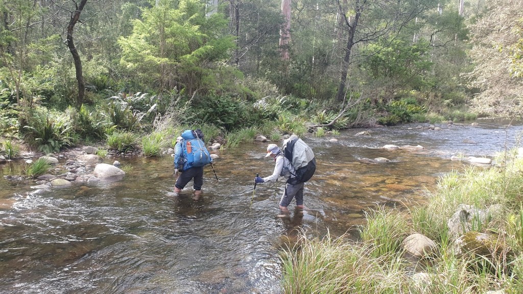
Then the rain stopped. Tents began to quiver and the sound of several pressure stoves blossomed in the gloom. Hans emerged: a Swiss carpenter, his handlebar moustache and superhero emblazoned cap indicated he was ready for action, and it wasn’t long before the group gathered at a site one hundred metres upstream, where we intended to cross the rising Wonnangatta River.
There Jopie outlined the day’s route. We were aiming for a campsite at Viking Saddle, a small clearing situated between The Viking and The Razor. The distance wasn’t great: approximately seven kilometres. However, it would take a full day to arrive as we climbed eight hundred metres and attained two distinctive summits, before negotiating The Viking’s north-western cliff and descending two hundred metres through uprooted mountain ash in an area decimated by a recent winter storm.
There are various methods for crossing a fast-flowing, swollen river. Hans, that Man of Action, and being a carpenter, could not contain a biblical impulse. Fully clothed, he entered the river on the south bank and exited via the north like Moses parting the Red Sea.
Soon, we had all managed to successfully cross the river and regrouped on the north bank, while considering the next — and perhaps most difficult — obstacle of the entire walk: a ‘1 in 2’ climb (one metre ascent for every two metres walked), out of the river valley to a small ridge running east to west and separating the Wonnangatta from one of its myriad tributaries. Steep, but short — yet combined with a 22-kg pack and overbearing humidity… well, I need not say any more.
Once the tributary was crossed we fought our way through a patch of dense, wet fern and other harsh vegetation, before emerging on a pleasant slope — the beginning of the climb to our first 1,300-metre highpoint, south-west of the South Viking.
As we followed the spur upward there occurred several changes in the landscape. The spur narrowed and turned to rock. Sub-alpine grasses and mountain ash were replaced by tufts of spinifex and the ubiquitous snowgum. The thick humidity present at seven hundred metres was swept away by the snap of an alpine wind. Cloud coagulated around us, the mist rolled in, and one of our party, Michael, a visitor like myself, disappeared from view.
The ‘1 in 2′ climb straight after breakfast had curbed the group’s enthusiasm but Michael appeared to have suffered a little more than the rest of us. Having some inclination toward the mysteries of first aid and that almost transparent 11-kg pack, Rod left the leader’s group and joined him at the rear.
Nobody in the party had traversed, or knew of anyone who had traversed, this route to the South Viking. (I had dropped off the summit once before, opting for the relatively gentle descent of a broad spur further east.) We did not know what to expect as we approached the South Viking in heavy mist until the sight of a perpendicular bluff made its presence felt, appearing to block any further ascent. Momentarily, it looked as if we would be forced to spend excruciating hours battling scrub in hostile country by pushing horizontally east — until Jopie’s navigational skill eased into gear.
Viewed from a great height, we must have resembled a procession of colourful ants teeming over stonework as we negotiated an interconnected system of channels in the escarpment, soon reaching the summit of the South Viking. The difficult aspect of the ascent was over. The South Viking and The Viking were connected by three low-lying saddles. We hurried through each one and arrived at the summit of The Viking. There we hauled packs through a rock chimney, picked up the track to Viking Saddle, and descended through an apocalypse of trees ripped from the ground by a mini-tornado.

I was thankful not to have been camped in the saddle on the night that monster tore through the bush. Hearing a fully grown tree hit the ground is unnerving enough. To have fifty or so crashing around a tent at night would have been a bushwalker’s nightmare.
A large group had already arrived at the saddle. With the inclusion of our eight tents, a small colony appeared. The sky cracked open once again — and this time the rain was permanent. Confined to our tents, we were wet, hungry and tired. But we were well and truly alive. Not that there was any question about the safety of the party. It’s just that city life dulls the senses and a sophisticated urbanite soon forgets his primal origins.
After an hour of heavy rain, the weather shifted. A noticeable breeze blew into the saddle via the headwater of the West Buffalo River. At dusk, a break appeared in the eastern sky. Someone from the other group had persisted in the rain and lit a campfire. A strange shamanic conduit, it drew others to its primal dance. Shadows flickered across faces alive in the darkness, smoke rose into the night air, and I fell asleep and dreamed of prehistoric times.
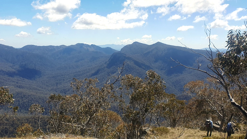
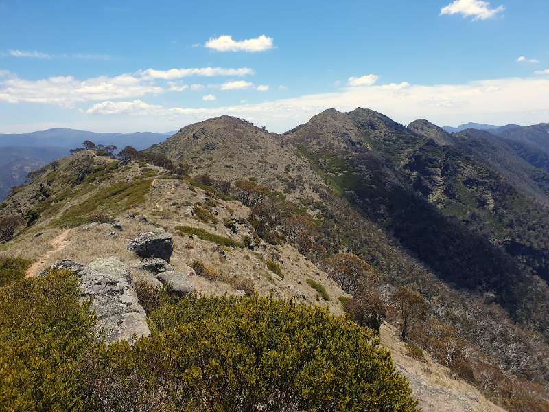
As predicted, the rain cleared overnight. We were off early, picking our way through fallen timber as we climbed toward The Razor. To my surprise, there was such a thing as a promising grey sky. But an hour later, as we emerged from the forest and scrambled up the conglomerate slabs of The Razor, low cloud still enveloped the northern face of The Viking.
Even so, it was the first unrestricted view we’d had of the surrounding area for two days.
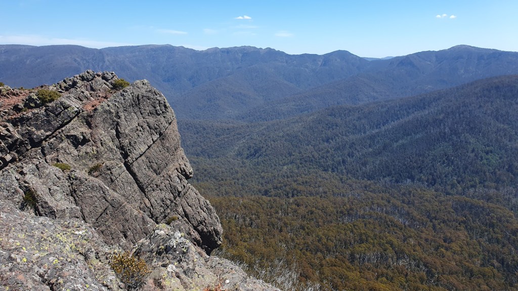
Standing on the crest of one of many conglomerate slabs, we could see the many sloping spurs and interconnecting ridges descending north toward the remote Catherine River. To the west, the Australian Alps Walking Track fractured as it struggled along intractable rock towards Mt Despair. This was to be our intended route for the day, the objective being Mt Speculation. Jopie had other ideas.
Having walked the circuit several times, I had never reached the summit of The Razor. Once on the summit, after a slow kilometre of rock hopping through trackless terrain, the side-trip proved eminently worthwhile.
An increase in temperature flushed low-lying cloud from The Viking’s north-eastern flank. The cliffs marking the Australian Alps Walking Track’s easterly descent to Barry Saddle appeared. Vertical, and like the weather-beaten brow of a forlorn, lost explorer, the mid-mountain cloud closed in once again and The Viking disappeared.
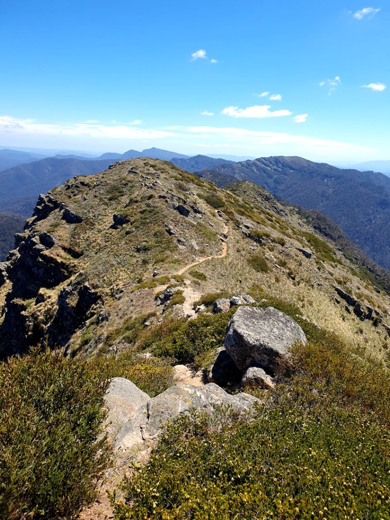
An hour later, after reclaiming our packs, we were back on the walking track leading west toward Mt Despair. Despite slow going along the southern crest of The Razor, the mood of the group had lightened. The most difficult aspect of the walk was behind us. Hans was telling tall stories once again. We would soon be setting the pace along an obstacle-free track over Despair and down to Catherine Saddle, a headwater of the Wonnangatta River. As a gash in the cloud widened and blue sky appeared for the first time in two days, we discovered there was no irony intended in the name ‘Mt Despair’.
It was a relief to finally see the sun. But why had it chosen to appear, and why had the temperature increased just as the ascent of Mt Despair had begun?
In the past, a solid rest after considerable physical exertion had always left me ready and willing. However, the cumulative stress produced by carrying a heavy pack through rough country for three days was beginning to tell. And we still had the severe climb from Catherine Saddle to Camp Creek prior to the summit of Mt Speculation to complete.
It was well past 5.00 pm as we descended the grassy, sun drenched western slope of Mt Despair. After a hard day, this was not a great time for preparing to climb one of the higher mountains (1,630 metres) of the Wonnangatta Moroka sector of The Alpine National Park.
At Catherine Saddle, two routes presented themselves.
A foot track headed straight up the northeastern flank of the mountain while the old Wonnangatta Track (ambitiously referred to as Speculation Road) followed the twelve-hundred-metre contour around the same flank, then ascended Camp Creek via a shallow valley.
Bob and Michael chose to follow the contour. I was tempted, but on a blind impulse followed Jopie, Rod, Tim and Hans over an embankment and up the hill.
Halfway up, I wished I’d chosen the contour. Without exaggeration, I thought my lungs would pop. But after twenty years of bushwalking, during which I had walked the entire Australian Alps Walking Track and been whacked by second-stage hypothermia on Mt Anne in South West Tasmania, I had integrated into my bushwalking a highly sophisticated technique for dealing with mind-altering pack-carries up the steep flanks of mountains.
Growling.
Believe me, growling will get a beaten walker to any summit, any time — although the worried look I received from Hans suggested I had completely lost my marbles. But growl I did, and once again it got me up the mountain. Yet I was grateful that Tim, a trainee nurse, was also present in case my growl became a heart murmur and I collapsed in cardiac arrest.
Finally, we reached Camp Creek. After some slow tent-erecting, during which I found it difficult to recognise the front end of the tent from its rear, water was obtained from Camp Creek.
Bob and Michael arrived, a small fire was lit, and once again, cloud descended upon us, dampening everything except our spirits. We settled in for a restful night as the temperature hovered at five degrees.
We were high in alpine country, directly beneath the summit of a 1,600-metre mountain. We may not have been able to see past our noses, but our bellies were soon full. For the first time during the entire trip, the opportunity presented itself to sit around the fire and share what was already a memorable experience. From intimations of shamanic ritual and prehistoric dreams, to a bushwalker who chose to growl, instead of howl, when confronted by cardiac arrest. But soon, we were all so tired, each one of us silently slipped away, disappeared within a lick of mist, and quietly went to sleep.
Birdsong broke the silence; what species of bird it might have been, I had no idea. Instead of going back to sleep, I lay on my back in the dark as the bird’s repeated rhythms crystallised thoughts in my sleepy brain. Somewhere in the valley below, a second bird of the same species responded to the first bird’s solo. A fugue ensued; something was afoot in the natural world. I could feel its aura surrounding my tent.
A high mountain sunrise was one thing, but this show was otherworldly. Tim and I were up and out of our tents, captivated by a violet streak illuminating the tip of a distant mountain. No one else was awake. We were two children watching the birth of a new world. I had seen many a sunrise during my forty years in the mountains, but this was THE sunrise.
After an hour frolicking in the mellow light of a glorious mountain morning, it was time to get serious. Before us lay the Crosscut Saw: a ten-kilometre rocky spine separating the Wonnangatta and Howqua rivers, leading back to Macalister Springs. Our trip along the Razor Viking circuit was concluding.
From the summit of Mt Speculation there would be that descent through the bluff at Horrible Gap during which Bob would lose his footing and hang suspended in mid-air from a rickety tree branch. There would also be that climb to Mt Buggery, the name of which would elicit a grim laugh from Tim as he encountered its sharpness. Without doubt, there would be the pain derived from four days of stress upon a body that failed to recover after the climb to Buggery’s summit. Every step, every adjustment of the load upon my back, every swivel of the hips and resulting unobstructed view into valleys east and west would evoke within me an ecstatic sense of the Victorian Alps — their inspiration, my infatuation, and the wonder that makes bushwalking in those alps an exhilarating experience. There would be all this and more as we cracked jokes after meeting up with Lance on the heath at Macalister Springs, before arriving to fresh fruit at Howitt car park.
But that moment of truth all bushwalkers strive for had passed.
As we left Camp Creek and climbed toward the summit of Mt Speculation, the old path had ended and a new trip had begun.
RAZOR VIKING: WITH A TWIST by Tony Reck © 2025
Photos: John Terrell © 2025
